White feather walks

Join me on my journey around the UK, SCOTLAND and beyond researching my family lines and spiritual quest of contentment and abundance
The white feather walks started when I was looking seeking someone, i would go to the spiritual church and further my skills in clarevoyancy, literally i went to one and that was it for me, the messages kept coming through loud and clear, one way was white feathers. i would have an idea and see a white feather and know that it was right. These white feathers have taken me to so many different places or accompanied me to court showing they are there with me.
I think Arundel castle was one of my favourites as i did it on my own and met a lovely guy that helped take some of my pics for me, it was the first of my solo sophies and from then ive always done them with confidence either with my kids or enjoying my own company.
I think Solo sophie helped to, so pop along to her website shes fantastic.

MacDonalds. Castle Tioram
Castle Tioram, the ancient fortress of the MacDonalds. Castle Tioram was built in the mid 13th century and extended in the 14th century as a testament to the independent rule of Rough Bounds by the Clanranalds, Lords of the Isles.
It is situated in a strategic location on a rocky tidal island of Eilean Tioram at the confluence of Loch Moidart and the River Shiel, occupying the whole summit of the rock in Moidart.
The Castle is surrounded by a pentagonal, round angled, curtain wall dating from 13th century with later modifications. The curtain wall has a barrel vaulted entrance facing landward (northeast) with a small machicolation above (i.e. a floor opening to allow discharge of objects onto attackers of the castle). There was also a back entrance (a postern), that was later blocked in during the late 17th century.
The main building inside the curtain wall consists of an apartment block above a cellar, dating from the early 17th century, extending an earlier wooden feasting hall asnd small 14th century tower. The building has large window openings, a projecting gabled stair tower (stair turret) and large internal apartments. On one side, the building supports an additional storey containing corbelled bartizans and castellation.
The Castle’s reputation as an impenetrable stronghold is borne of its design, construction and location. It has been taken only once and then by deception and cunning. It was set alight in the 18th century on the order of Allan, 14th chief to prevent it falling into the hands of the Government. It now stands as a sombre testament to the changing fortunes of the Clanranalds.

Cardiff Castle
The medieval castle in Cardiff was erected on the site of a Roman fort from the first century BC who guarded the then border, during the conquest of the Celtic tribe of the Silures. As the Roman border moved west, the fortifications became less needed and were replaced by two smaller defensive objects north of the original site. In the middle of the third century, in the face of the threat of Irish pirate raids, the Romans erected another, fourth fort, whose remains were later incorporated into the castle. The fort was probably garrisoned at least until the end of the 4th, early 5th century, but it is not known when it was finally abandoned.
From the late 60s of the 11th century, the Norman conquest of southern Wales began. The progress of the invaders was marked by the construction of castles, often in the areas of ancient Roman buildings. Their re-use meant significant savings of time, money, and especially building materials. The Norman castle in Cardiff was erected by king William the Conqueror in 1081 or by Robert Fitzhamon, Earl of Gloucester and follower of the king in 1091, after defeating Iestyn ap Gwrgan, the last independent ruler of Glamorgan. Over the following years, it became the main center of Robert’s reign over the region. Cardiff was then located near the sea, which solved the supply problem, was also well protected by the rivers Taff and Rhymney, and controlled the old Roman road running along the coast.
Robert Fitzhamon was killed as a result of after battle injuries in 1107, and his daughter and heiress, Mabel, married Robert, the illegitimate son of English king Henry I. The king gave Robert the earldom of Gloucester and made him Lord of Glamorgan. The new ruler of the castle at the request of king Henry, imprisoned in his fortress the second prince of Normandy and the elder brother of the king, also Robert, who stayed in the castle against his will from 1126 to the death in 1134. Around 1140, Robert, Earl of Gloucester rebuilt the central part of the castle from timber to stone, probably because of the Welsh revolts a few years earlier.
Robert died 7 years later, and his successor was his son William, who died in 1183 without a male heir. The castle then passed to the prince and later king John, through engagement with William’s daughter, Isabel. In 1217, the castle passed into the hands of Gilbert de Clare, the son of Isabel’s sister. It was from now an important family seat in South Wales, although de Clares preferred to live in their castles in Clare and Tonbridge. Gilbert’s son, Richard de Clare, the sixth Earl of Gloucester, at the end of the thirteenth century began another construction works to raise the castle’s defenses. It could have been caused by the threat of hostile Welsh prince Llywelyn ap Gruffudd.
ARUNDEL CASTLE
HOME TO THE HOWARDS
Arundel Castle is the historic home of the Dukes of Norfolk, having been occupied by their line for over 850 years. Amongst the dynasties to have inhabited Arundel Castle, the highly influential Howard family are most notable, and still occupy the eminent site today. With aspects dating from the medieval and early modern periods, Arundel Castle is the perfect visit for anyone looking to immerse themselves in Britain’s fascinating past.
Arundel Castle history
The first structure on the Arundel Castle site was built in the 11th Century by the Normans after the invasion of William the Conqueror, with the earthworks and first buildings completed by 1070. William d’Aubiny, the first Earl of Arundel, inherited the castle in 1138, followed by the FitzAlan family in the 13th century who undertook a large programme of renovation.
In the 16th century, Arundel Castle came into the possession of the Howard family when FitzAlan heiress Mary married Thomas Howard, 4th Duke of Norfolk. His grandfather had been the eminent 3rd Duke of Norfolk and uncle of both Catherine Howard and Anne Boleyn, Henry VIII’s ill-fated second and fifth wives. Thomas Howard, 4th Duke of Norfolk himself would be executed by Elizabeth I for his involvement in the Ridolfi plot, in which he conspired to marry Mary, Queen of Scots and place her on the throne.
During the English Civil War, Arundel Castle was besieged twice – first by the Royalists who successfully captured the site and then by the Parliamentarians, whose siege lasted 18 days. Following this, Parliament ordered the slighting of the castle, a process that deliberately damaged it to reduce its value as a royal military stronghold.
In 1846, Queen Victoria and Prince Albert stayed at Arundel Castle, before which the 13th Duke of Norfolk undertook a large remodelling scheme to accommodate them. The scheme paid off, with Victoria commenting on the beauty of the castle and the friendly reception she received.

Arundel Castle today
Today, Arundel Castle remains a vast complex, with many original features still intact such as the Norman Keep, medieval Gatehouse, and Barbican. It is home to an impressive array of priceless artwork, such as works by Van Dyck, Gainsborough and Canaletto, as well as a vast collection of furniture, sculptures and tapestries.
The displays also include possessions of Mary, Queen of Scots, and the collection of furniture especially purchased for Queen Victoria’s visit, including the bed she slept in!

TURNBERRY CASTLE RUINS
NOW OCCUPIED BY TRUMP GOLF COURSE
It was an extreeamley wild and windy day when we arrived at Turnberry Cadtle,
There isnt much left but all phottos ar below to see.
Turnberry Castle occupies a rocky spit of land which now also houses the Turnberry lighthouse, and can be accessed by crossing the Trump Turnberry Golf course. There are a number of sections of ruined wall which indicate that it was once an impressive courtyard castle, and it is best appreciated at low tide, when it is possible to walk out onto the rocks to see the walls.
The castle was probably built in the 13th century and was a property of the Earls of Carrick. This Earldom was formed out of the defunct Lordship of Galloway in the late 12th century, and after two Earls the line ended in Marjorie, Countess of Carrick. In 1271, the widowed Countess married Robert de Bruce of Annandale, and although this angered the King, Bruce was eventually granted the title Earl of Carrick. Their eldest son was to become King Robert I, and it is commonly believed that he was born at the castle. In 1297, during the early Wars of Independence, the castle was burned by William “le Hardi” Douglas. After his coronation and swift exile in 1306, Bruce returned to Scotland in 1307, landing at his former home Turnberry, repaired and reoccupied by the English. He did not succeed n taking it, but forced the garrison to abandon the castle. In 1310 it was slighted on the instructions of Bruce in line with many other castles, but accounts submitted by the Baillie of Carrick between 1326 and 1370 show that it was repaired, with sums in excess of £165 being spent there. Unfortunately the castle does not feature again in records, so we do not know its subsequent history under the Stewarts.
The castle was defended by a substantial curtain wall and ditch across the peninsular, presumably with a gate entered via a wooden bridge across the ditch. There is no evidence of wall towers, but it seems probable that the land-facing wall was supplied with these. As the remains are overgrown with centuries of earth and grass, it is impossible to identify this without field work on the site. The northern end of the ditch was overlooked by the one tower we can be certain of, the large keep. The rest of the peninsular was surrounded by curtain walls which followed the irregular outline of the rocks, here and there bridging awkward inlets instead. There was at least one sea gate, defended by a large portcullis, and it was through this gate that Bruce entered the castle in 1307. The sea gate leads to a badly ruined vault forming the basement of the keep, and was supplied with stairs leading up to an enclosed courtyard. An eroded cave in the rocks may have been a second sea gate. Today this leads to what may have been another covered vault, or else the castle dock. There is no evidence to suggest there was permanent access to this area from the castle, so if this cave existed in the 13th century, access to the dock would probably have been by removable ladders! The irregularly shaped outer ward is largely destroyed and is occupied by the Turnberry lighthouse installation.

Merlins Cave and Tintagel Castle ruins
Merlins Cave and Tintagel Castle ruins
HISTORY OF TINTAGEL CASTLE
The site of Tintagel Castle has been inhabited at least since the late Roman period, and a community flourished here in the 5th to 7th centuries. In the 12th century Tintagel gained literary fame when Geoffrey of Monmouth named it as the place where King Arthur was conceived. These Arthurian associations may have inspired the fabulously rich Richard, Earl of Cornwall, to build a castle at Tintagel in the 1230s, and the enduring legend still ensures Tintagel’s international renown.
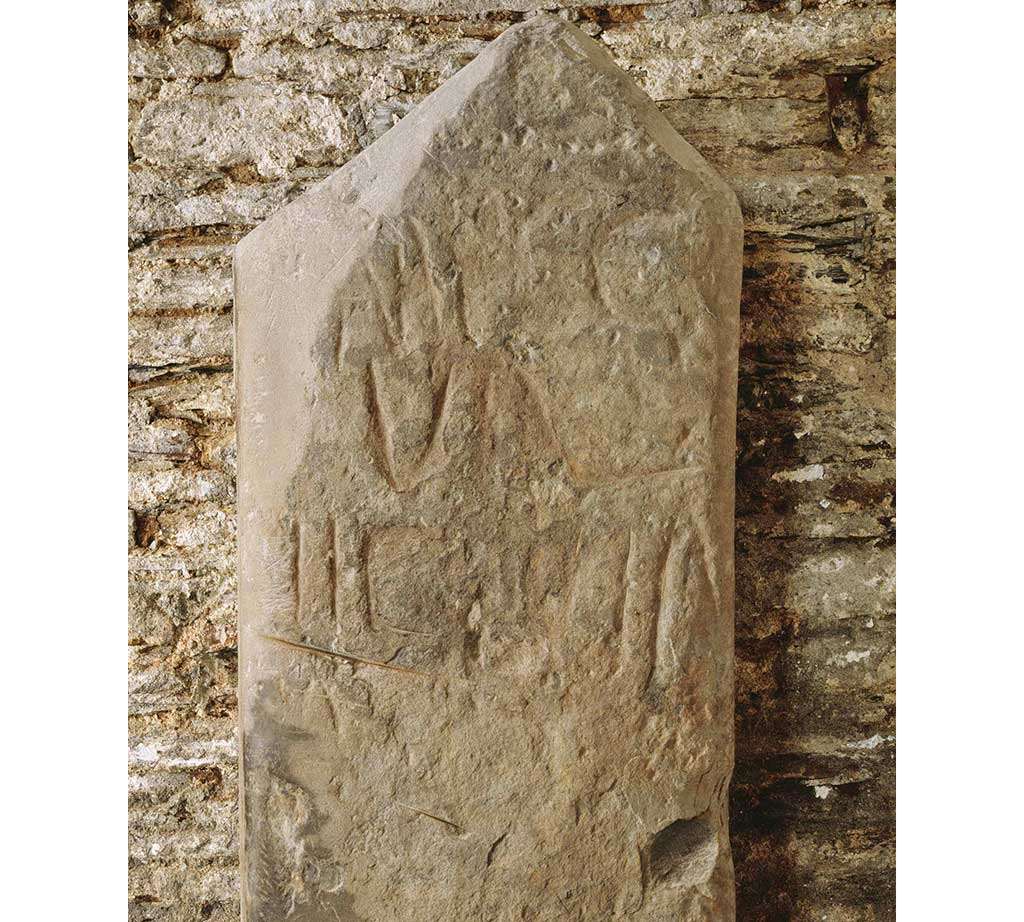 A Roman inscribed pillar found in Tintagel parish churchyard and now in the church. It is inscribed IMPCG VAL LIC LICIN, which translates ‘Emperor Caesar Galerius Valerius Licinanus Licinius’. Licinius reigned from AD 308 until AD 324
ROMAN OCCUPATION
No conclusive evidence has been found that there was an Iron Age fort at Tintagel, although the site would have been similar to those of Iron Age promontory forts found on other south-western headlands, such as on Willapark headland, 1 mile east.
Similarly it is uncertain how much activity there was on the site in the Roman period. The two Roman honorific markers from the area, one now in Tintagel church and one at Trethevy 1½ miles east, suggest some presence in the area in the 3rd and 4th centuries. Various small finds, including pottery and some late 3rd- and early 4th-century Roman coins, also suggest activity on the headland at this period. However, this seems unlikely to have been significant.
DOWNLOAD A PLAN OF TINTAGEL CASTLE

A reconstruction of Tintagel as it may have looked in about 700, showing the island dotted with simple houses© Historic England (drawing by Aaron Watson)
TINTAGEL IN THE 5TH TO 7TH CENTURIES
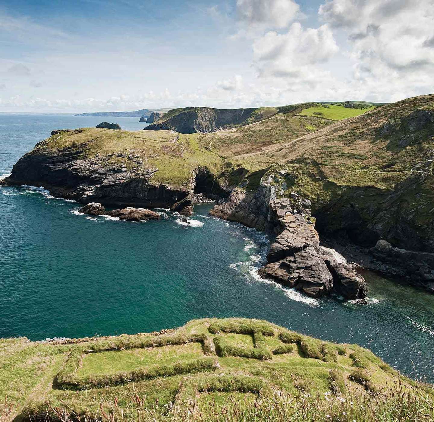
From about AD 450 until about AD 650 Tintagel was a prosperous and highly significant site, closely involved in trade with the Mediterranean world. The island was covered with many small rectangular buildings, some visible today. A large bank and ditch, also still visible, defended the landward side of the narrow neck, which at this date may have been as high as the land on either side.
The site’s precipitous headland (the island), connected to the mainland only by a narrow neck of land, makes it strongly defensible, with extensive views over the whole southern part of the Bristol Channel. Most unusually it also has supplies of fresh water.
The most likely explanation of the site is that it was a secular stronghold of the then rulers of Dumnonia (Devon and Cornwall). British kingship at this period was peripatetic, so Tintagel would probably have been one of several royal sites in Devon and Cornwall.
The headland could also have been defensive, possibly a response to settlement in its hinterland by Irish-speaking colonists at the same period, known from monumental stones with Irish inscriptions found in north-east Cornwall and down to the Tamar valley.
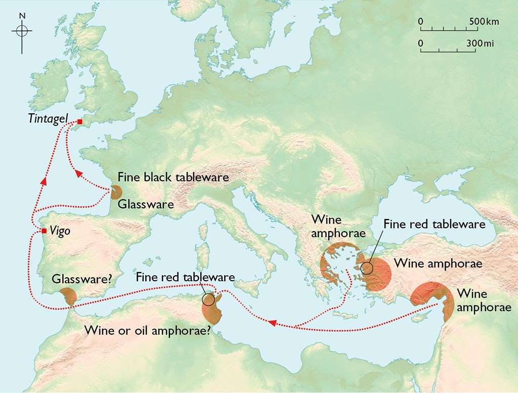 Pottery and glass were imported to Tintagel from all over the Mediterranean during this period. This map shows the known sources of these wares
TINTAGEL AND THE MEDITERRANEAN WORLD
Both the importance and the date of the early occupation of the site are evident from the many pieces of imported Mediterranean pottery, including high-quality tableware, found on both the mainland and the island. Such fragments have been found all over western Britain, but Tintagel has by far the largest quantity so far discovered.
Fragments of Mediterranean glass of the same period have also been found. These goods arrived in the south-western peninsula by ship as part of a systematic trade which brought luxury goods and in exchange presumably took tin, the most distinctive and desirable commodity produced here, back to the Mediterranean.
The pottery finds, combined with the buildings on the island, some of which have hearths, suggest intensive occupation at this period.
 The early settlement remains on the eastern slopes of Tintagel island, looking across to the rocky headlands of the Cornish coast. The dramatic landscape was vividly described in Geoffrey of Monmouth’s ‘History of the Kings of Britain’
THE BIRTH OF THE ARTHURIAN LEGEND
After the mid-7th century there is little evidence of activity on the headland for over 500 years. In about 1138 Geoffrey of Monmouth’s History of the Kings of Britain gave the figure of King Arthur, the legendary ruler of Britain, Ireland and large parts of continental Europe, its international fame.
The History contains the earliest written mention of Tintagel in the tale of how Arthur was conceived there by Uther Pendragon, King of Britain, the result of his magically assisted seduction of Queen Igerna (Igraine), wife of Duke Gorlois of Cornwall.
The reasons for Geoffrey’s use of Tintagel can only be guessed. He associated Arthur closely with Cornwall, and Cornish legend may have preserved a folk memory of the earlier importance of the site, perhaps as a stronghold of the rulers of Cornwall. Geoffrey described its dramatic physical attributes, evidently appreciating its romantic nature.
Independent support for such a folk memory comes from the legend of Tristan, known from French and German poems later in the 12th century, which seem to have drawn on Cornish legends. Tintagel appears in these poems as the court of Tristan’s uncle, King Mark of Cornwall.
The visible remains on the headland would have helped to keep alive a memory of its former importance.

A reconstruction of Richard of Cornwall’s castle as it may have looked in about 1240© Historic England (illustration by Aaron Watson)
RICHARD OF CORNWALL’S CASTLE
In May 1233 the newly created Earl of Cornwall, Richard, brother of Henry III, bought the ‘Island of Tyntagel’, together with ‘Richard’s castle’, from Gervase de Tyntagel (whose father, Robert, had changed the family surname from Hornicote to Tintagel).[1] ‘Richard’s castle’ was presumably built by the earl himself. If so, it was begun between 1225, when King Henry granted him the county of Cornwall, and 1233, when the transaction took place.
It is likely that Earl Richard was keen to exploit Tintagel’s international literary fame. In about 1242 he used the castle to receive his nephew, the Welsh prince Dafydd ap Llywelyn, whose allegiance to Henry III was questionable.[2] Any doubts over Richard’s own loyalty, however, were dispelled when soon afterwards he campaigned in Wales on Henry’s behalf against Dafydd.
Apart from this episode, little is known of how much the castle was used, if at all. Earl Richard was involved in international politics, going on crusade to the Holy Land in 1240 and being elected King of the Romans (ruler of Germany) in 1257. From that date until his death in 1272 he is unlikely to have had much time to visit Cornwall.
READ MORE ABOUT RICHARD AND TINTAGEL The remains of the battlemented curtain wall, built between 1240 and 1260, which surrounded the island courtyard
TINTAGEL IN THE LATER MIDDLE AGES
By 1337, when the Duchy of Cornwall was created, the great hall of the castle was in decay;[3] the constant coastal erosion of the site may have caused a partial collapse. Edward the Black Prince, the first duke, had the hall reworked into smaller buildings.
A small staff, including a chaplain, was employed to look after the castle, and in the late 14th century two high-status prisoners were brought there from London for secure keeping. A survey made in 1583 recommended that the headland should be strengthened against possible foreign landings, but by 1600 the site was largely deserted.[4]
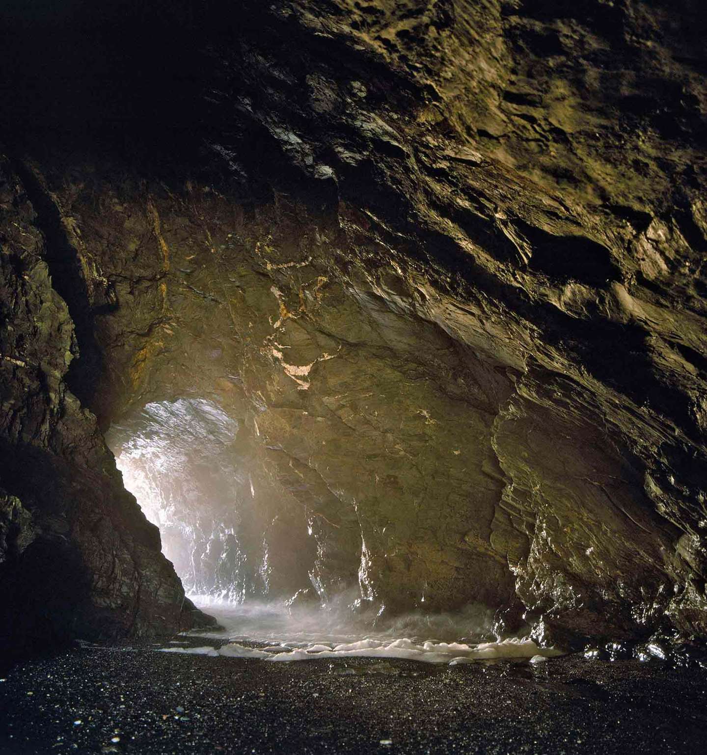 The cavern on the west side of the Haven beach, which has been known since the late 19th century as Merlin’s Cave
THE GROWTH OF THE ARTHURIAN LEGEND
Although the castle was little used, imaginative legends continued to flourish. In about 1480 the antiquary William Worcestre gave Tintagel as the place of Arthur’s birth as well as his conception; and in 1650 the name King Arthur’s Castle is first found.
By this date references to King Arthur and to the castle had become an inextricable mixture of local folklore and literary legends. In medieval romance Caerleon, and then the legendary Camelot, not Tintagel, had occupied the role of King Arthur’s castle.
About the Author
Oliver Padel is an authority on Cornish place-names and history, and president of the English Place-Name Society. He has also written about the legends of Arthur and Tristan.
ALL PHOTOS IN GALLERIES BY ABBE DEVERE
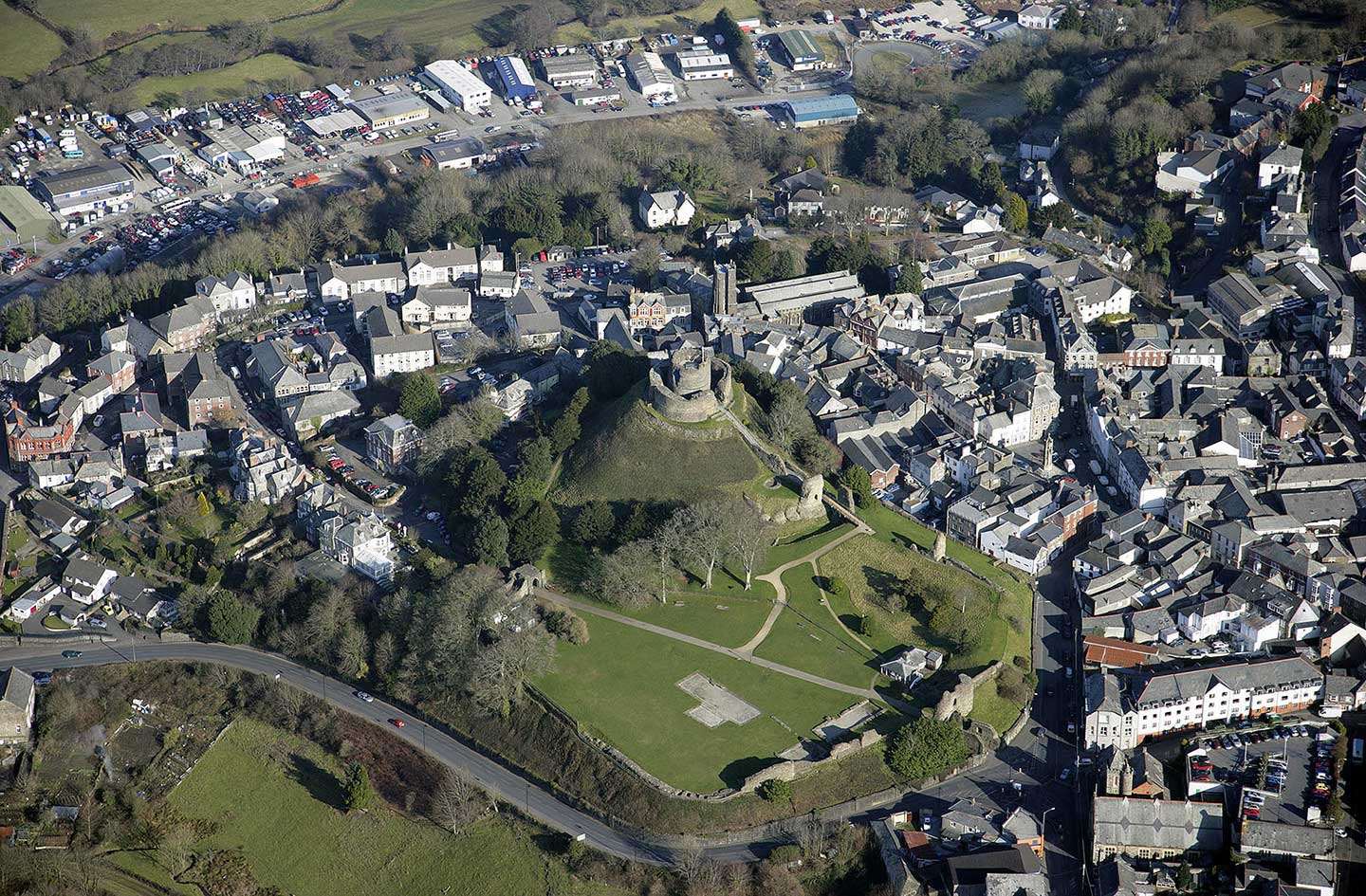
Launceston Castle
A reconstructed view of Launceston looking north-east, showing how the castle and town might have appeared in the late 12th century© Historic England/English Heritage Trust (illustration by Peter Urmston)
FOUNDATION
Count Brian of Brittany, a leading supporter of King William I (William the Conqueror), established a castle here around 1068. The site was strategically important, overlooking a deep valley and close to a road crossing of the river Tamar, which forms the eastern border of Cornwall. Launceston and Trematon were the only two castles in Cornwall listed in Domesday Book (1086), when Count Robert of Mortain, the second most important man in England, held them both. This established a pattern in which Launceston Castle was held by some of England’s most powerful figures.
Before the castle’s foundation, settlement in the area was focused to the north at Lanstefan, across the river Kensey. In the 1090s Lanstefan’s market was transferred to the outer bailey of the castle, and additional settlement soon followed. By the 13th century the town, surrounded by a wall, had grown to the extent that it was regarded as the natural place from which Cornwall should be administered.
The mound at the north-east corner of the castle originated in the late 11th century. The buildings and defences were initially of timber, but later in the 12th century stone began to be used, including a ‘shell keep’ on the mound, which survives, though much altered. From the 1180s documents begin to mention other buildings inside the castle, including the ‘king’s chamber’ and a prison.
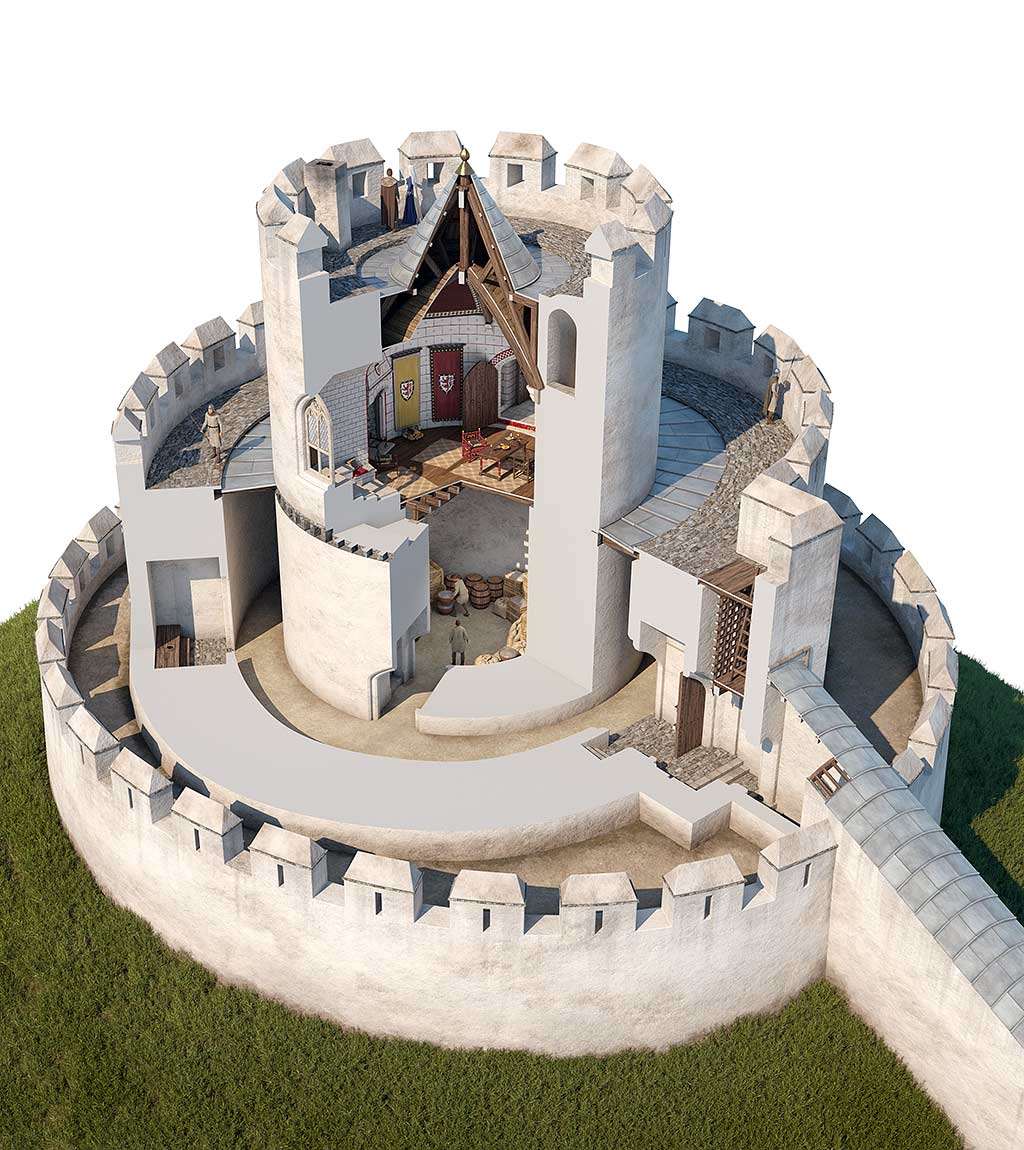 A cutaway reconstruction of the shell keep at Launceston in the 13th century, after Earl Richard had refashioned it© Historic England/English Heritage Trust (illustration by Josep Casals)
EARL RICHARD AND THE CASTLE’S DEVELOPMENT
In May 1227 King Henry III invested his younger brother Richard (1209–72) with the title Earl of Cornwall. Richard held estates across England as well as many castles and manors, but his control of the tin industry of Cornwall and Devon brought him a huge income, making him one of the richest men in England. Clever, cultured and politically astute, Richard achieved international celebrity in 1257 when he secured election by the prince-electors of Germany as their king, or ‘King of the Romans’. This made him the leading candidate for the yet more prestigious role of Holy Roman Emperor, although he died before he could achieve that goal.
Earl Richard rarely visited Launceston or Cornwall in person, preferring to leave his officials in charge, but he is known to have stayed at the castle at least six times, including his 51st birthday. He reconstructed many of the castle’s buildings in stone, including a hall, a kitchen and chambers in the bailey. He also re-fashioned the shell keep, adding a central round tower and creating a unique multi-tiered tower.
In Earl Richard’s time Launceston Castle was unchallenged as the place where officials administered justice and collected money on his behalf. Under his son Edmund, Lostwithiel in central Cornwall was promoted as a rival ‘capital’, with a luxurious new castle nearby at Restormel, in which the earl would more often stay. Nonetheless, Launceston Castle retained its historic significance as Cornwall’s most important courthouse and the county gaol.
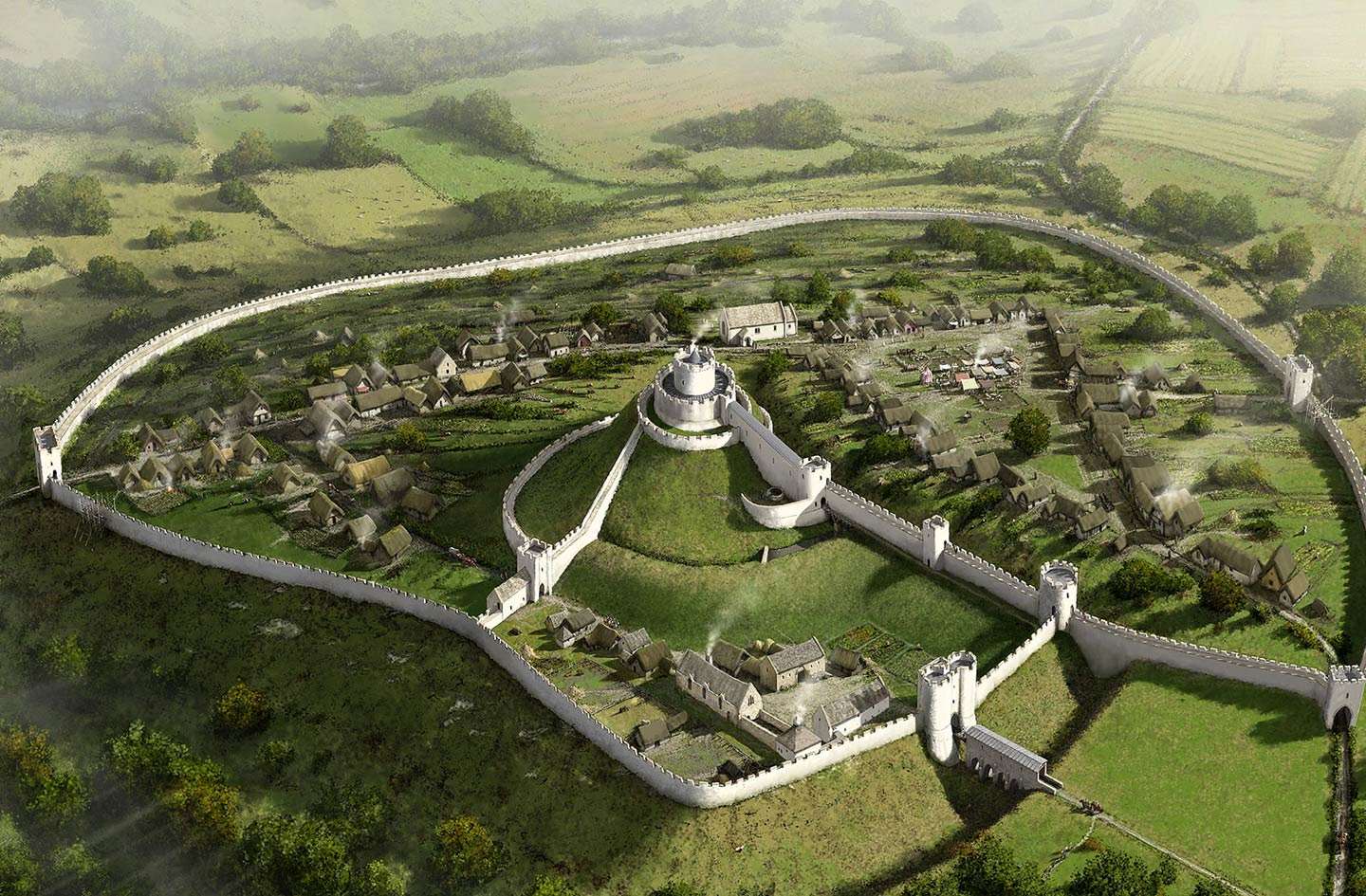
Move the sliding bar to compare a reconstruction of Launceston Castle and town as they may have looked in about 1270 with a similar view today. (Illustration by Peter Urmston © Historic England/English Heritage Trust)
 The tomb effigy of Edward the Black Prince, made shortly after his death in 1376, in Canterbury Cathedral© Angelo Hornak/Alamy Stock Photo
THE DUCHY OF CORNWALL IN THE LATE MIDDLE AGES
In 1337 Edward III made his eldest son (also named Edward) the Duke of Cornwall. The Duchy of Cornwall, which still exists today, has estates in Cornwall and Scilly but also in other parts of England; the title of duke is given at birth to the monarch’s first-born male child.
Officials surveyed the six-year-old Duke Edward’s new property for him in 1337. At Launceston, they found that the castle’s buildings had been badly neglected. Of the buildings on the motte, for example, they reported that
[There is a] passage leading from the castle up to the High Tower, newly covered with lead, but whose steps are defective. And there are in the same tower two chambers whose doors and windows are of no value. And the aforesaid tower has two stone curtain walls, of which one portion containing by estimation three perches has fallen to the ground.
It was the same story throughout the castle; even the gaol was ‘badly and inadequately covered with lead, and another prison called the “Larder”, weak and almost useless’.
Under Edward (later Prince of Wales, and better known as the Black Prince), Launceston and other castles in Cornwall were repaired. His correspondence with his officials occasionally mentions the deer park on the castle’s western side, an important recreational asset especially during the duke’s occasional visits. Rarely, he also gave orders for the castle’s fortifications to be strengthened: clearly in times of unrest and conflict, Launceston Castle might be called upon to uphold the duke’s control of the territory. And at all times it was used most intensively as a prison, holding people accused of crimes until they could be tried in the great hall.
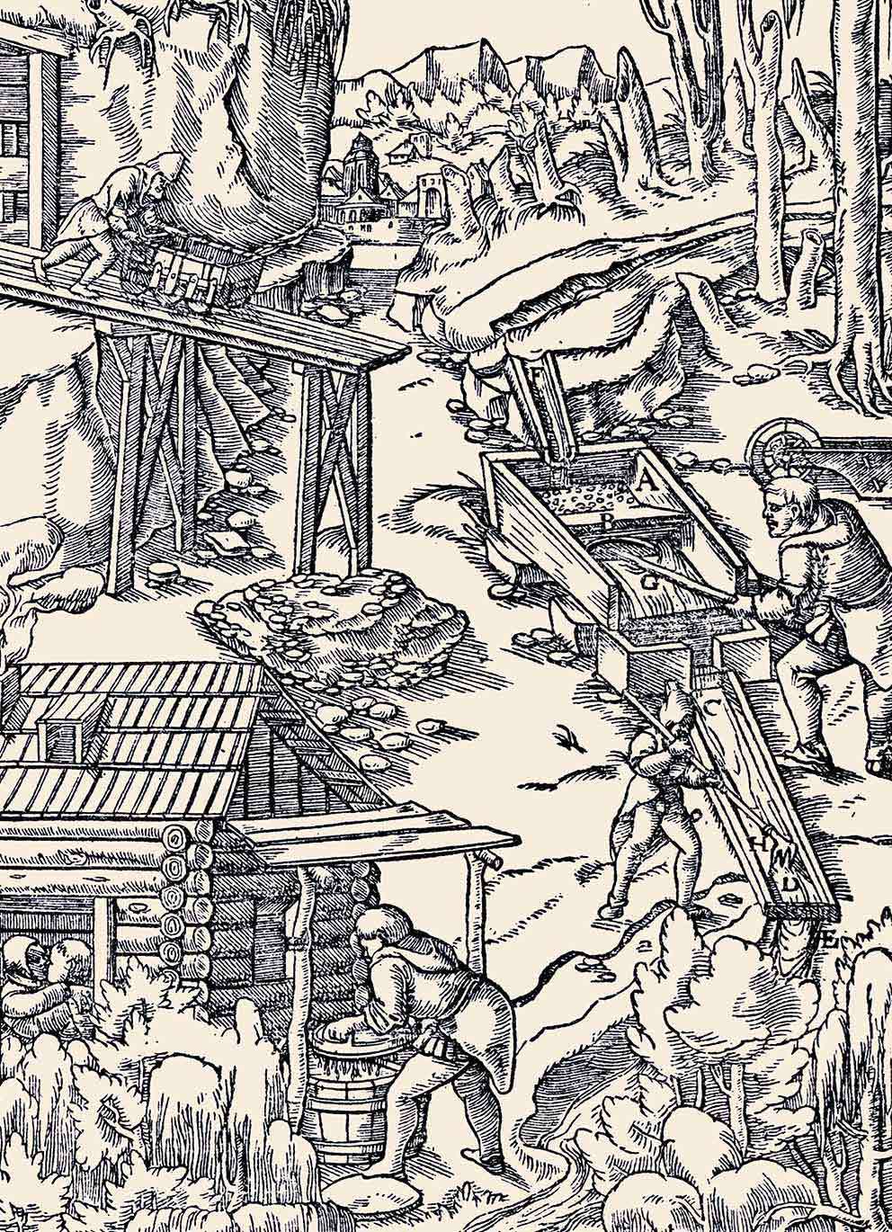
LAUNCESTON CASTLE AND THE TIN INDUSTRY
The tin industry of Cornwall and Devon was a jealously guarded monopoly of the Earls and Dukes of Cornwall in the Middle Ages and afterwards, and its control was a matter of the greatest importance. Tin was heavily taxed, bringing figures such as Earl Richard and Duke Edward a huge regular income. But in return, those engaged in the industry were allowed their own legal system and considerable independence.
Castles such as Launceston and Restormel played important roles in the industry, as places of security in which sensitive operations such as the assay (testing) of tin ingots for purity (known as ‘coinage’) could be carried out safe from outside interference or fraud. For example, in October 1346 the duke ordered that the only two manufacturers of pewter in Cornwall should be based inside the castles at Launceston and Restormel.
Image: A 16th-century woodcut showing tin streaming – the usual medieval method of recovering shallow tin deposits. After digging away the overlying soil, the tinners would divert a stream of water into the deposits, washing away the sand and silt to leave behind the heavier, tin-bearing gravels
© Alamy Stock Photo
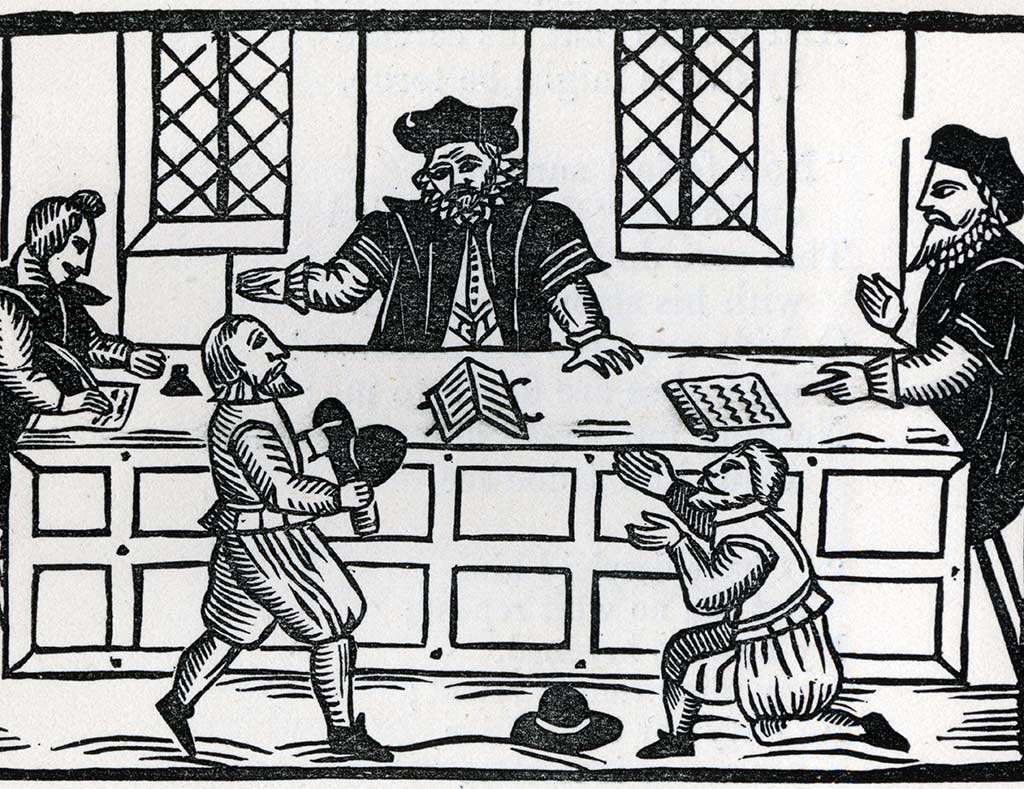 A woodcut from about 1600 showing a judge, lawyers and litigants in a courtroom. County assizes were held at Launceston Castle at this time© Chronicle/Alamy Stock Photo
‘CASTLE TERRIBLE’
In the late 15th and 16th centuries, the relationship between Cornwall and the government of England was marked by successive rebellions, followed by oppressive responses. As the central place for the administration of Cornwall, the castle was the setting for the trial, imprisonment and execution of Cornish rebels. In 1577 the Roman Catholic priest Cuthbert Mayne was held in the castle, and after his brutal execution in the town’s market-place his head was displayed over the castle gate. Memory of such events probably lies behind the local nickname ‘Castle Terrible’, which was recorded by the Cornish antiquary Richard Carew in the early 17th century.
By the 17th century, the day-to-day running of the castle largely fell to the mayor of Launceston and the castle gaoler rather than a Duchy official. The dilapidated great hall was no longer adequate for court sessions and after the 1640s the courts moved to a building in the town, leaving the castle solely as a prison.
As well as local prisoners, captured foreign sailors were occasionally confined in the castle. At this time, many prisoners were kept in and around the north gatehouse, but at the end of the 17th century a new county gaol within the castle bailey replaced or supplemented this.
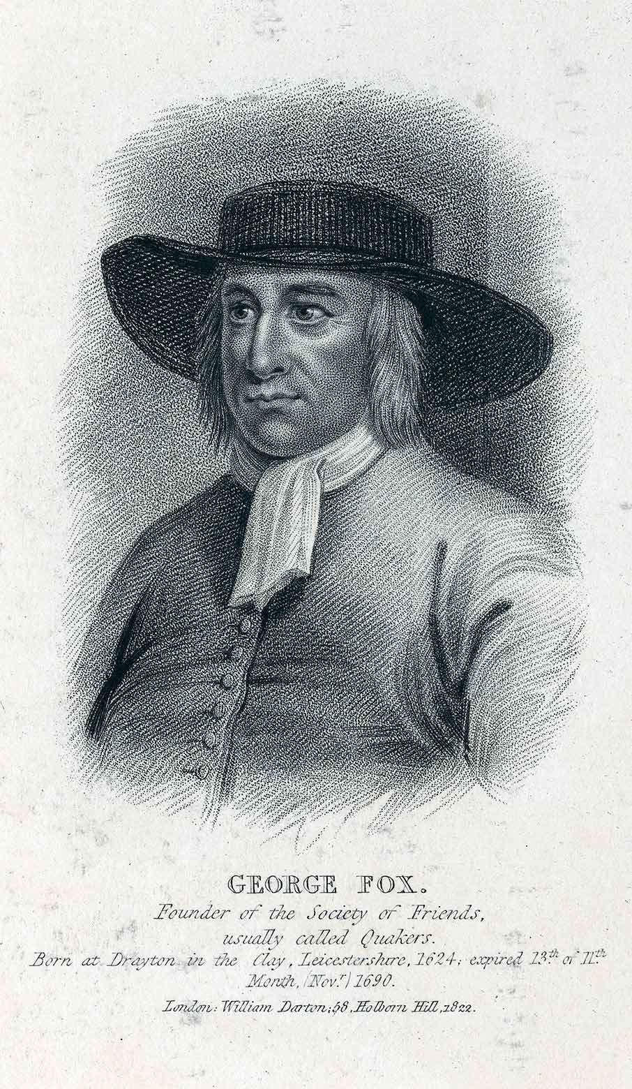
GEORGE FOX IN PRISON
George Fox, the founder of the Society of Friends (Quakers), was arrested in 1656 during a preaching mission to the West Country, ostensibly for having long hair. For this, and the additional offence of not removing his hat in court, he was held prisoner at Launceston Castle for about eight months.
Fox left a graphic description of the squalid conditions of his cell in the north gatehouse, nicknamed ‘Doomsdale’:
The place was so noisome that it was observed few that went in did ever come out again in health. There was no house of office [latrine] in it, and the excrement of the prisoners that from time to time had been put there had not been carried out (as we were told) for many years. So that it was all like mire, and in some places to the tops of the shoes in water and urine …
At night some friendly people of the town brought us a candle and a little straw, and we burned a little of our straw to take away the stink. The thieves lay over our heads, and the head jailer in a room by them. … It seems the smoke went up into the room where the jailer lay; which put him into such a rage that he took the pots of excrement from the thieves and poured them through a hole upon our heads in Doomsdale, till we were so bespattered that we could not touch ourselves nor one another.
Fox described how reports of this ill-treatment generated widespread sympathy and helped promote his cause. Eventually he was moved to a better cell, and allowed to exercise in the castle courtyard.
Image: A 19th-century portrait of George Fox
© Chronicle/Alamy Stock Photo
 Detail from an engraving by Samuel and Nathaniel Buck of the castle in 1734, showing the dilapidated state of the castle walls
FROM PRISON TO PLEASURE GARDEN
The castle became still more unkempt as the 18th century progressed. An engraving of 1734 shows the walls and towers with many gaps, covered with vegetation, and with only the small prison-house inside. Thirty years later the mayor of Launceston, Coryndon Carpenter, helped speed the ruination by demolishing the upper storey of the north gatehouse and part of the north curtain wall. This was to make room for a new house and garden for himself; Eagle House still stands today.
The prison building was extended in the late 18th century with the addition of an exercise yard, but conditions inside were still woeful – in a popular local saying, ‘like Lanson gaol’ meant something squalid and disorderly.
In the 1840s, nearly 800 years of the castle serving as the main prison of Cornwall came to an end with the closure of the prison in favour of the gaol at Bodmin. The prison was demolished and the castle courtyard landscaped. In the process the workmen discovered the remains of the prison cemetery.
From 1843 the Duke of Northumberland, who had leased the castle, laid out the eastern part of its grounds as a pleasure garden, with winding paths, trees and shrubs.
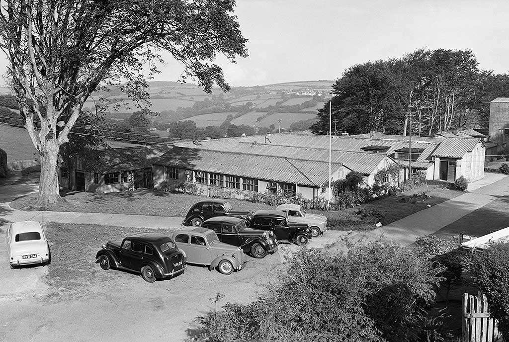 A 1954 photograph showing Castle Green filled with huts. These were built in 1944 as a military hospital, and later used by local government officials© Historic England Archive
MODERN TIMES
The castle continued as a pleasure garden for the town through the first half of the 20th century. Public events occasionally took place there, including a spectacular pageant in 1931, in which hundreds of costumed volunteers re-enacted episodes from Launceston’s history. The growing popularity of travel to Cornwall (by rail and road) brought more and more visitors to Launceston and the castle.
The Second World War saw the castle pressed into official use one last time. The western half of the bailey became the site of a temporary hospital for the US Army, who were assembling in Cornwall and across southern England in preparation for the D-Day landings. The hospital buildings remained in use by local government officials after the war, and survived until the 1960s. But from 1951 the castle was in the guardianship of the Ministry of Works, and since 1984 it has been managed by English Heritage. History of Launceston Castle | English Heritage (english-heritage.org.uk)

SCORHILL STONE CIRCLE
Scorhill Stone Circle
Scorhill Stone Circle, near the hamlet of Gidleigh, has been called Dartmoor's finest stone circle, a bold claim considering the remarkable number of prehistoric monuments on Dartmoor.
Some of that praise is down to the fact that Scorhill was spared the attention of Victorian 'restorers', meaning that it is relatively original, despite having had several stones removed and others damaged over the years.
The stone circle stands near the confluence of the North Teign River with its tributary the Wallabrook. The circle is 26.8m (88 feet) across. There are 34 stones remaining, 23 standing and 11 fallen, though these only account for a portion of the circle.
It is estimated that there would have originally been 65-70 stones needed to complete the circle. Some stones were taken away to repair the Gidleigh leat, or drainage channel. Other stones show marks left by stone cutters.
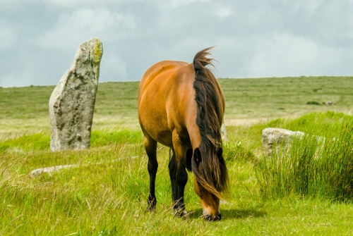 A Dartmoor pony grazing at Scorhill
Interestingly, the stones are not spaced evenly. The largest stone is 2.5m (8.1 feet) and there is a very tall and wide (1.8m x 1.5m) stone fallen over in the SSW of the circle.
The circle dates to the Bronze Age (roughly 3200–600 BC) and is part of an ancient landscape on the moor that includes six hut circles, three cairns and a 'reave' or field boundary of earth and rubble. Leading away towards the south is a double stone row, now almost completely buried beneath the turf.
A short walk south on Scorhill Down leads to the Teign-e-ver clapper bridge over the North Teign River, and near the bridge is the striking Tolmen Stone, a large boulder like a doughnut with a hole bored through it, said to be a focus for fertility rituals and healing ceremonies.
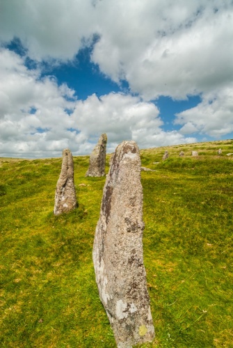 Looking along the circle
Did the stone circle have an astronomical purpose? On Midsummer Eve the sun sets behind the tallest standing stone at Scorhill. Coincidence or intentional alignment?
Flint artefacts found on Gidleigh Moor and now in the Torquay Museum show that the moor has seen human activity as far back as the Mesolithic period (8,500-4,000 BC).
MYTHS AND LEGENDS
Local folklore suggests that it was also the focus for a different kind of ritual; women who had been unfaithful had to wash in Cranmere Pool then run around Scorhill Stone Circle three times, then pass through the Tolmen Stone before kneeling to pray by the stones for forgiveness.
Those who were refused forgiveness were crushed by falling stones, which is why you see so many fallen stones today. Another version of the story says that the faithless woman had to make her way to Grey Wethers Stone Circle for her final task.
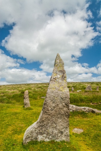 A striking triangular stone
Another local legend says that the stone circle was once the home of a ferocious ogre who would kill and eat any sheep that strayed too close to his home.
Two cart tracks lead through the circle, though according to legend horses will refuse to pass through the stones.
Horses may refuse, but Dartmoor ponies don't! On my last visit to Scorhill, I found a herd of ponies grazing happily amongst the stones and using them for scratching posts.
GETTING THERE
The simplest way to reach Scorhill Stone Circle is to park at Scorhill Farm, at the end of a lane heading south-west from Gidleigh. There is a small parking area near the farm. From there you take the footpath that leads south-west from the end of the road. Take the first fork left then the second fork right. The trail leads directly across Scorhill Down to the stone circle.
From the circle, it is well worth a short walk south to the Teign-e-ver clapper bridge and the Tolmen Stone, on the north bank of the river.
About Scorhill Stone Circle
Address: Gidleigh, Chagford, Dartmoor, Devon, England
Attraction Type: Prehistoric Site - Stone Circle
Location: Park at Scorhill Farm, outside Gidleigh, and follow the obvious trail south-west across the moor for 500m.
Location map
OS: SX654873
Informaation found on Scorhill Stone Circle, Dartmoor (britainexpress.com)
I was chatting to someone on you tube who told me that the real use for stone circle was to generate water from wells and springs below, obviously I further researched this last night and found this great website The Mystery of Ancient Stone Circles - The Deep Water Enigma - Ancient Egyptian Connections (willemwitteveen.com)


DONATE TO SUBSCRIBE TO THE REST OF THE WEBSITE
Encouraging Subscribers to assist with the ongoing preservation of history, Add your details for interest in the upcoming Secret forum, When we have 100 subs, The forum will open.